Data by postal code area in the Paavo service have been updated
NewsThe Paavo statistical service based on postal code areas has been updated again to correspond to the latest regional division of 2026. The service now includes up-to-date data for 2024 on nearly all topics, and users can view development in their area more closely than before.
The service Paavo – postal code area statistics offers an extensive overview of the characteristics of different areas. Included are data on such as:
- population structure and educational structure
- households' size, stage in life and income
- buildings and dwellings
- workplaces and main type of activity of inhabitants
The service is free of charge for all, and it contains both statistical data and map data that can be downloaded as a database or through the interface service. The data are widely utilised for monitoring regional development, decision-making and learning more about areas of residence, for example.
Data for 2024 are now included on all topics but for one exception. The updating of data on workplace structure is delayed for reasons related to statistics production, and the data will be added to the service during 2026.
The service contains time series for statistical data starting from 2010, which allows examinations of long-term development trends. At the same time, the postal code classification has been updated to correspond to the official classification of 2026.
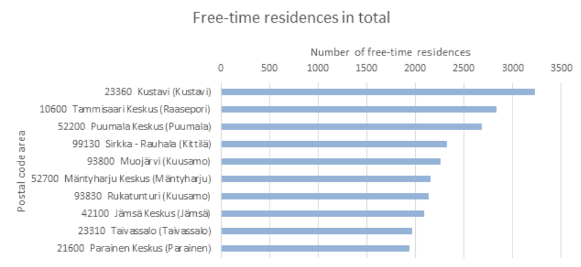
As an example of data by postal code area, the number of free-time residences in 2024 was extracted for the figure below. The number of free-time residences was highest in the postal code area of Kustavi, over 3,000. There are plenty of other interesting things to explore in the Paavo service.
Figure 1. The number of free-time residences in 2024
Source: Statistics Finland
Contact information
Oula Inkeröinen
Senior Statistician
+358 29 551 3883
erityispalvelut@stat.fi